
Grove Pond
Grove Pond
- 72 acres
- A shallow pond created by human-made impoundment
- Part of the 538 square mile Nashua River Watershed
- Located within the Squannassit ACEC (Area of Critical Environmental Concern)
- Receives its water via a stream flowing south from Balch Pond and passing underneath East Main Street, as well as from Bowers Brook flowing north from Harvard
- At the outlet at the western tip, water flows west into Plow Shop Pond
- Restricted use (boating only, swimming and fishing discouraged) due to the presence of heavy metal contaminants in the sediment
- Pirone Park, with its “Kiddie Junction” playground, is located on the north shore
And if you want to learn more…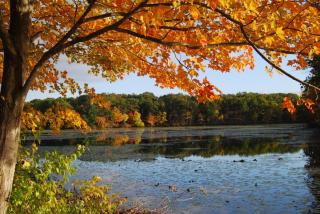
General Description and History
Grove Pond is part of the chain of hydrologically-connected ponds and streams that bisect Ayer and eventually convey their waters into the Nashua River: Long Pond > Sandy Pond > Flannagan Pond (fed into also by Pine Meadow Pond) > Balch Pond > Grove Pond > Plow Shop Pond > Nonacoicus Brook > Nashua River.
Grove Pond is characterized by the extremely dense growth of submerged and floating-leaf aquatic vegetation, giving it a higher density of plant growth, biomass, and species richness compared to most other Ayer ponds. Non-native species, especially fanwort but also variable leaf milfoil, are unfortunately an abundant presence, and small patches of a relatively recent newcomer, invasive water chestnuts, were also found at the eastern end of the pond. (Starting in the summer of 2022, a group of volunteers led by PACE [People of Ayer Concerned about the Environment], began a multi-year project of hand-pulling the water chestnuts in an effort to prevent their spread throughout Grove Pond and eventually into the Nashua River.)
This is one of Ayer’s many ponds created by the construction of human-made dams and mills over the last few centuries. In Ayer, on its north shore, residential development abuts Grove Pond along with Pirone Park. In the 19th century, much of what is now the East Main Street neighborhood was part of the Silas Nutting estate. In 1910, his daughter, Sarah J. S. Nutting Bennett, conveyed her “Nutting’s Grove” to the Town of Ayer to be used as a public park. Grove Pond was likely named in reference to Nutting’s Grove. Now called Pirone Park, it is managed by the Ayer Park Department and serves as the location of athletic playing fields, a walking path, and Kiddie Junction playground (currently closed for removal, remediation, and rebuilding due to arsenic contamination – see below).
The southern shore of Grove Pond abuts what used to be Fort Devens, a major United States Army military installation. Established as Fort Devens in 1917 (initially called Camp Devens), it was decommissioned in 1996. Part of the former fort was reactivated as a United States Army Reserve installation and includes a federal prison, but the rest – now simply ‘Devens’ – was turned over for civilian residential, commercial, and industrial use as a “regional enterprise zone” currently under the jurisdiction of MassDevelopment.
Because of Grove Pond’s proximity to an active military base in operation for 79 years, pollutants from Fort Devens, as well as from some local industries, were able to drain into Grove Pond. This caused extensive environmental contamination that led to Fort Devens being listed as a superfund site in 1989 by the federal Environmental Protection Agency. Heavy metal contamination, especially arsenic, as well as the detection of mercury and chromium, have been found in Grove Pond. While boating is permitted, because the deep sediments in this pond are so laden with contaminants, fishing and swimming are strongly discouraged. For this reason, the Ayer Conservation Commission does not include Grove Pond in its aquatic vegetation management program: disturbing the contaminated sediment would be risky and would send more contaminants further downstream. It would also be prohibitively expensive to try to remove the enormous amount of contaminated sediment present in this pond.
The Town of Ayer Department of Public Works maintains wells at Grove Pond (and at Spectacle Pond) to supply public drinking water to Ayer residents. The wellhead area is part of an Aquifer Protection District. Water is not drawn directly from the pond itself but from these wells, far, far below where the known contamination is bound into the sediment. Water drawn from these wells is treated to remove iron, manganese and arsenic -- and more recently PFAS (Per- and Polyfluoroalkyl Substances – aka “forever chemicals”) -- before being pumped into the distribution system.
Trophic Status
Ponds, lakes and other surface waterbodies can be evaluated on scales that rate their trophic status. This status indicates the amount of ‘biological productivity’ (or total weight of living biomass at time of measurement) that a waterbody sustains. Biomass in a waterbody is usually dominated by either aquatic vegetation or algae. Waterbodies can range from oligotrophic – less biomass/’good’ water quality; mesotrophic – moderate biomass/’fair’ water quality; and eutrophic to hypereutrophic – high/dense biomass/’poor’ water quality. Too many ‘nutrients’ in a waterbody (especially from phosphorus and nitrogen runoff from stormwater, nearby fertilizer use, septic systems, etc.) will lead to an increase in plant and/or algae growth and a decrease in water quality as the process of eutrophication continues. While eutrophication is a natural process of nutrient enrichment in aquatic ecosystems that takes place gradually over time, it can be dramatically accelerated by the impact of human activities that increase the flow of nutrients into waterbodies and their surrounding watershed.
According to the Geosyntec Consultants study of Ayer Ponds completed in 2016, as measured by the Carlson Trophic State Index (TSI) model, Grove Pond is rated as mid-mesotrophic. The Carlson TSI uses water clarity and measurements of Total Phosphorus (TP) and Chlorophyll-a to make its assessment. Nevertheless, Geosyntec concluded that based on observed conditions, Grove Pond is clearly a eutrophic waterbody “with high biological productivity, very dense aquatic plant growth throughout, and deep organic sediments.” A different model for evaluating eutrophication, the Vollenweider model, is in agreement with this conclusion, rating Grove Pond as highly eutrophic. This model uses measurements of a pond’s ‘flushing rate’, the TP load entering the pond from external sources, and the internal TP concentration already there (i.e. from sediment and plant decomposition). Geosyntec used all this data to recommend that, given Grove Pond’s shallow depth combined with its very deep layer of organic sediment that supports dense plant growth but is also contaminated, efforts and expenditures to reduce the TP load entering the pond from external sources would “yield very little benefit to pond water quality.”
Impairment
The Federal Clean Water Act (effective in 1972) governs water pollution in the United States, and requires states to identify waterbodies that do not meet EPA standards and are designated as “impaired.” In the most recent report, Grove Pond is listed as a Category 5 impaired waterbody due to the presence of not only non-native aquatic vegetation but also contaminated pollutants, including arsenic and mercury. (By contrast, Sandy, Flannagan, and Pine Meadow ponds are all listed as Category 4c level impaired due to the presence of non-native species but no pollutants.)
This sign project was funded by a community grant from the Nashua, Squannacook, and Nissitissit River Wild & Scenic Stewardship Council.